Santa Catalina Island
Written by Brent Humphreys
January 26, 2010
As many of you know, I frequently travel for work. A lot of people have the idea that work travel entails flying in first class and eating at the finest restaurants while wining and dining. In mysituation, that is definitely not the case. A typical business trip for me starts at 2 or 3am as I get up to catch an early flight at an airport 200 miles away. After driving a few hours, and surrendering my dignity to the Transportation Security Administration, we are driven like cattle onto an airplane to sit in seats that are too small with people that cough more than a healthy human should. After arriving at my destination, I travel to the customer's site. I work in manufacturing, so we are not talking about palatial downtown offices, or scenic business parks. The locations are often in tough neighborhoods or in boring Industrial parks. In manufacturing time is money, and opportunities to do some of my work are driven by staffing, and production needs, so we often work odd, or long hours. A typical work day is 12 hours with gusts up to 18. Definitely not glamorous.
This week, I found myself flying to Orange County, CA on Monday to attend training classes Tuesday thru Thursday. This presented the unique situation in which I would arrive at my destination at noon local time, with no scheduled commitments for the remainder of the day. Immediately after landing at John Wayne airport, I drove around to the other side of the field to Sunrise Aviation to see if there were any aircraft available for a local flight. There was an opening, so I reserved a 2 hour block in a Cessna 172.
Arriving a couple of hours later for my appointment, I had studied the terminal area chart and had lots of ideas. Options included a cruise along the coast line, a tour through one of the many scenic valleys or a trip up to Van Nuys for a landing on the famous 16 Right. Another option, and my favorite, was a flight out to Catalina Island. When I spoke to the CFI I would be flying with, we discussed all of these options, the airspace, and the amount of time we had. We both agreed that Catalina would be a good fit for all of our requirements.
The briefing for the flight was relatively easy. We would take off to the West, turning North along the shoreline, climbing to 6,500 ft. We would turn West toward Catalina before reaching our target altitude to avoid the Los Angeles Class Bravo. The crossing is about 20 miles over water, so we need some altitude to minimize the distance we are out of gliding range to land. With our plan made, we headed out to the airplane.
John Wayne (SNA) airport is a mixed use General Aviation and commercial airport. Security is pretty tight to get to the flying side of the airport. To get in, I rode in the instructors car, where he had a security pass, a personal badge, and I had to present my drivers license. We were able to drive to a parking area near the aircraft. Preflight was easy. We were to be flying a P model Cessna 172. This is the model with 13 low point drains for the fuel system, so we spent a good amount of time just checking fuel.
Loaded in the aircraft, we called ground for taxi clearance before going through the startup checklist. We were cleared to taxi on the main taxiway behind a Southwest Airlines flight that had just landed. The aircraft started easily, and we were off. The SWA 737 was just passing as we got to the taxiway, so we gave it a wide berth. Taxi was straightforward and we were cleared for takeoff on the large runway.
After takeoff we were over to departure control until we cleared the Charlie Airspace. Once clear of the Charlie we were cleared to Squawk VFR. By this point we were approaching the coastline and we transitioned to a cruise climb turning North paralleling the shoreline. Passing through 4,500 ft we turned back to the West toward Catalina. The island was just barely visible through the haze and smog. Once we were above 5,000 ft, the peaks on the island were clearly visible.
Santa Catalina Island is about 22 miles long and 8 miles across at it's widest point. The island is about 22 Miles West, Southwest of Los Angeles. With a population of about 3,700, the Island has two towns : Avalon and Two Harbors. Wikipedia has a good article with lots of information on the island. Catalina hosts a single airport, referred to as "the airport in the sky" due to it's location near the islands highest point.
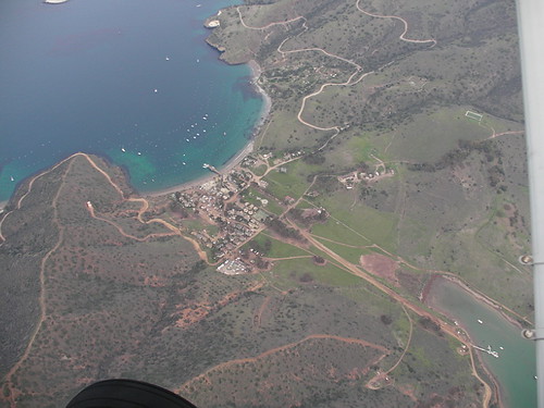
On our flight, we elected to not pay the $25 fee to land at the airport, and decided to circle the island instead. We flew north from the airport over Two Harbors, located at a narrow point in the island, the town has small harbors on the windward and leeward sides of the island.
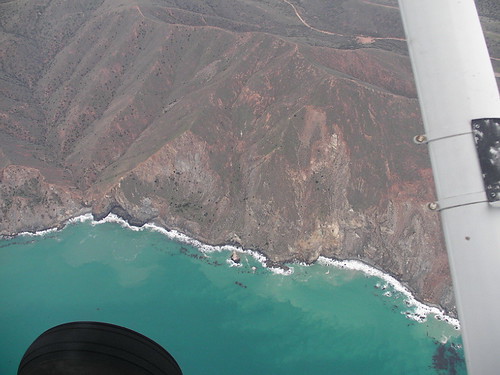
Next we did a slow turn to the West and continued South along the windward side of the island. The terrain was much steeper on this side of the island with lots of powerful waves crashing on the shore.
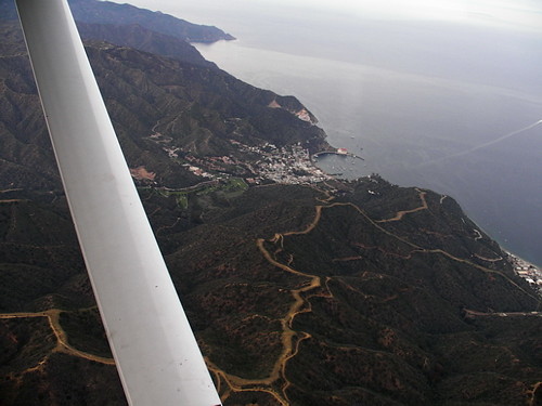
The city of Avalon appears to be an attractive little town, nestled in between the hills with a harbor on the leeward side. The city hosts a small casino and is primarily a tourist destination. There is a rock quarry near Avalon, on the southern end of the island.
After seeing Avalon, we began a climb back up to an altitude for a safer crossing of the channel. Once we were headed back across the channel, I got an appreciation of how large the Los Angeles area is. The area sprawled North and South as far as we could see from 20 miles out.
We aimed the aircraft for Long Beach harbor on our way back. As we approached land, we were busy calling out aircraft. There was a Baron 3 miles East same altitude, an Airbus 1,000 ft below us, and a Cessna passed under us about 500 ft below. There is no doubt this is busy airspace, but it is well laid out, and works well as long as everyone follows the rules.
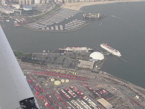
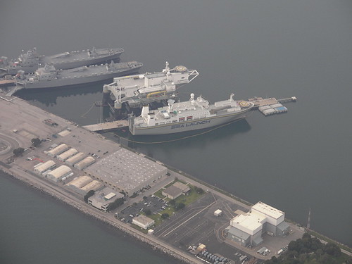
Crossing Long Beach harbor, we had a good view of the Sea Launch vessels that are used for launching satellites into orbit from sea near the equator. We also passed over the Queen Elizabeth cruise ship and the building where the Spruce Goose was kept before it was moved to its current location in Oregon.
As we crossed the pier at Newport Beach, we turned inland toward the airport. We were expecting a 45 degree entry to the downwind for 19R. As we approached the field the tower called, asking us to cross midfield at or above 1,300 ft to a downwind for 19L. From this point we had a great vantage point to survey for any approach traffic as we crossed midfield, and descended to pattern altitude at 850 ft. The approach path was clear, and we turned to base. Winds were a light 5 knot crosswind so final approach was easy with a flare just a tad bit late, but making up for it with a smooth touch down and roll out.
Looking at my log book, it has been 2 1/2 years since I logged any significant time as PIC. Understandably, I was a little curious how rusty my flying skills would be. I did all of the flying on this trip, save the times I asked the CFI to fly while I took pictures over the island, and I am pleased to report that I flew very well. I actually think I held altitudes much tighter than I have in the past. I walked away from my little adventure entirely satisfied. Regaining that thrill of flight, practicing a skill that I love doing, and doing it in a new environment different from any I have ever flown in before was the absolute best way to spend a free day on a business trip.